- December 15, 2025

As Dorian continues west toward Florida, currently as a Category 4 hurricane, local government officials in Flagler County and Volusia County have announced curfews that will begin Tuesday evening, Sept. 3.
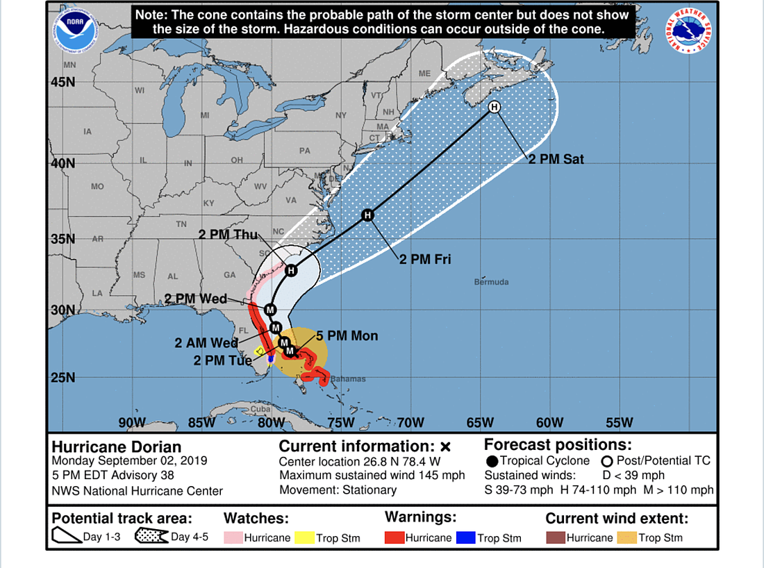
As of 5 p.m. Monday, Dorian had weakened from a Category 5 to a 4, but was showing a wider wind field and signs of a concentric eyewall structure, according to the National Hurricane Center's 5 p.m. update message.
The storm was moving so slowly as to be almost stationary, and winds were at 145 miles per hour and expected to decrease in the near term due to a possible eyewall replacement and an upwelling of cool water caused by the hurricane, according to the NHC message.
Dorian is expected to resume westward/northwestward motion Monday night into Tuesday as it pulls away from Grand Bahama Island, and to make its northwestward turn on Tuesday afternoon and weaken further as it moves parallel to the Florida coast.
"Only a small deviation of the track toward the west would bring the core of the hurricane onshore," the NHC message states. "A broad mid-latitude trough should help turn Dorian northeastward by Wednesday night, and the track models show the center coming precariously close to the southeastern United States coast."
The NHC is predicting life-threatening storm surge and hurricane force winds along parts of the Florida coast, as well as the coast of Georgia and South Carolina, regardless of the exact track of the center of the hurricane.
Flagler County has announced curfews to begin Tuesday in evacuation zones, according to a county government news release. Curfews for evacuation zones A, B and F will go into effect at 7 p.m. Tuesday, Sept. 3, until further notice. Those areas are under evacuation orders, and evacuations are ordered to be complete by 3 p.m. Tuesday, Sept. 3.
Zone A includes everything east of the Intracoastal, including Marineland, the Hammock and Flagler Beach along State Road A1A.
Zone B includes the neighborhoods off of Colbert Lane, all of the C-Section and the F-Section east of Florida Park Drive, and the F-Section east of Palm Harbor Parkway, plus the area east of Old Kings Road and south of State Road 100 including Bulow, Plantation Oaks and adjacent neighborhoods, plus western Flagler Beach and residences off John Anderson Highway.
Zone F is in western Flagler County, including areas near Dead Lake — St. Johns Park and the Haw Creek basin — because the St. Johns River, which feeds Dead Lake, is tidal.
You can also check your zone at http://data-fcmaps.opendata.arcgis.com/app/1fb593f31708445eb323972edd8c1625.
In Volusia County, an emergency curfew for cities and unincorporated areas east of the Halifax River will be 6 p.m. Tuesday to 6 a.m. Wednesday, and also 6 p.m. Wednesday to 6 a.m. Thursday.
A slight wobble in Dorian's path could change wind projections dramatically. Currently, winds in the Flagler/Volusia area are expected to remain under 15 mph on Monday, Sept. 2, according to the National Weather Center.
The wind will pick up on Tuesday, Sept. 3, reaching 20 mph — with gusts up to 30 mph — at 1 p.m., and continuing to climb slightly into the evening, with 25-mph winds and 40-mph gusts expected around 10 p.m.
Winds are expected to be 37 mph at 7 a.m. Wednesday morning (gusts at 55 mph) and climb to 39 mph (gusts of 57 mph) at 10 a.m. before beginning to decrease, reaching 32 mph (gusts 48 mph) by 4 p.m. Wednesday.
Flagler and Volusia are both under hurricane warnings as of Monday evening, Sept. 2.
For information on emergency shelters in Flagler County, go to https://bit.ly/2luO0uZ.
For information on emergency shelters in Volusia County, go to https://bit.ly/2k0ppxI.