- December 14, 2025

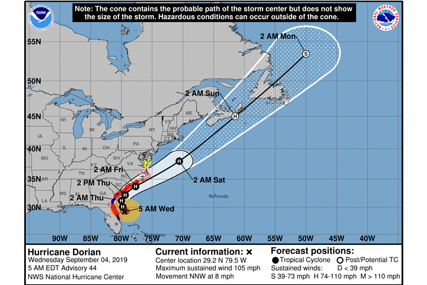
About 90 miles east of Daytona Beach, Hurricane Dorian is expected to move past Florida's east coast by Thursday, Sept. 5, according to an advisory by the National Hurricane Center.
Dorian is currently a Category 2 hurricane, with maximum sustained winds of about 105 mph. The storm is moving at about 9 mph toward the north-northwest, and this motion is expected to continue through Wednesday, Sept. 4. On this track, Hurricane Dorian will move parallel to the Florida east coast and the Georgia coast through Wednesday night. The center is forecast to move near or over the coast of South Carolina and North Carolina by Thursday through Friday, Sept. 6.
The storm is expected to weaken over the next few days, although Dorian is expected to remain a powerful hurricane during this time. Hurricane-force winds extend outward up to 70 miles from the center, and tropical-storm-force winds extend outward up to 175 miles.
The hurricane warning for the northeastern coast of Florida from the Volusia/Brevard County line to Ponte Vedra Beach has been changed to a tropical storm warning.
A storm surge warning is in effect north of Port Canaveral to the North Carolina/Virginia border. Water could rise 3 to 5 feet.
Dorian is expected to produce about 3 to 6 inches of rainfall, as well.
Finally, large swells will affect the northwestern Bahamas, and the entire southeastern U.S. coast from Florida through North Carolina during the next several days. These swells are likely to cause life-threatening surf and rip current conditions.