- January 17, 2025
-
-
Loading

Loading

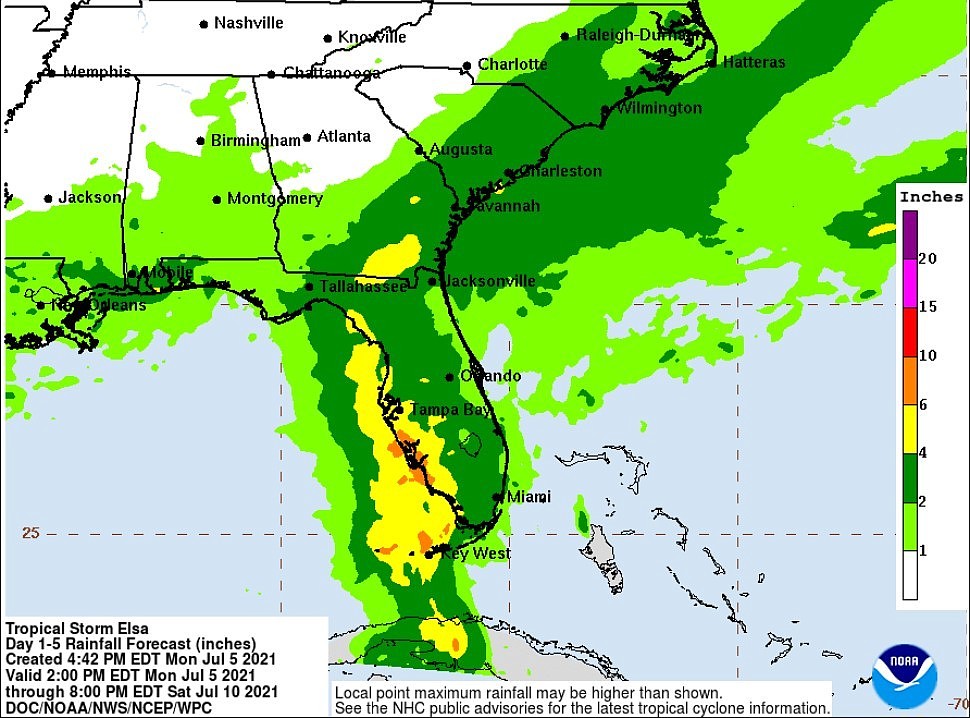
Areas saturated by recent heavy rains might see flash flooding because of Tropical Storm Elsa, which could reach hurricane strength when it makes landfall early Wednesday on the Gulf Coast, Gov. Ron DeSantis warned Tuesday.
At 8 a.m., Elsa was west of Key West, about 240 miles south of Tampa, with maximum sustained winds of 60 mph. It was expected to move north Tuesday off the Gulf Coast, causing rain, wind and storm surge.
While Elsa was forecast to make landfall early Wednesday in the area of Levy and Citrus counties in largely rural North Florida, heavy rains are expected along the eastern side of the weather system, which means most of Florida should feel impacts of the storm, DeSantis said during a news conference at the state Emergency Operations Center.
“It’s important that Floridians don’t focus on the (forecast) cone,” DeSantis said. “Impacts are expected well outside that area. And if you look at how the storm is, it’s incredibly lopsided to the east. So most of the rainfall is going to be east of the center.”
DeSantis said he doesn’t anticipate widespread evacuations, but he advised people to heed advice from local emergency officials and to expect that electricity could be out for several days. He expanded a state of emergency Monday to include a massive area of North Florida that includes Alachua, Columbia, Dixie, Franklin, Hamilton, Gilchrist, Jefferson, Lake, Lafayette, Madison, Marion, Sumter, Suwannee, Taylor and Wakulla counties. An earlier emergency order included Levy, Citrus and counties farther south.
“The state is well-equipped to handle the storm,” DeSantis added. “We have the state emergency response team working around the clock. We are going to increase the readiness to a level one. We normally wouldn't do that for a tropical storm. But given the part of the state that this is likely to impact the most, most of those (rural) counties are fiscally constrained counties.”
More than 6,000 utility workers have been placed on stand-by, while about 250 members of the Florida National Guard have been called up.
After expected landfall Wednesday morning in North Florida, the National Hurricane Center anticipates the storm will continue northeast into Georgia and the Carolinas.
“Tropical storm conditions are expected to spread northward into west-central Florida and the Florida Big Bend region tonight (Tuesday) and early Wednesday, where hurricane conditions are possible,” the center said in an 8 a.m. advisory. “Tropical storm conditions are possible in the watch area in Florida beginning late tonight.”
A hurricane watch was in place from Egmont Key, which is in the Tampa Bay area, to the Steinhatchee River in the area of Dixie and Taylor counties.
With tropical storm force winds extending outward 70 miles from the center, Key West International Airport on Tuesday morning measured a wind gust of 48 mph.
A tropical storm warning was in effect for part of the Florida Keys, from Craig Key westward to the Dry Tortugas, and along the West Coast, from Flamingo in Monroe County to the Ochlockonee River, which is in the area of Wakulla and Franklin counties in Northwest Florida.
A storm surge warning was in place from Bonita Beach in Southwest Florida to the Aucilla River, which is at the eastern side of Jefferson County. The warning includes Tampa Bay.
On July 4, President Joe Biden issued a federal emergency declaration in Charlotte, Citrus, Collier, DeSoto, Hardee, Hernando, Hillsborough, Lee, Levy, Manatee, Miami-Dade, Monroe, Pasco, Pinellas and Sarasota counties.
That came a day after Gov. Ron DeSantis issued a state of emergency in the same counties. DeSantis revised his order Monday to add Alachua, Columbia, Dixie, Franklin, Hamilton, Gilchrist, Jefferson, Lake, Lafayette, Madison, Marion, Sumter, Suwannee, Taylor and Wakulla counties. He also removed DeSoto, Hardee and Miami-Dade counties from his earlier order.
Jim Saunders contributed.