- December 15, 2025

The Volusia County Council and Volusia County School Board are hoping to reach a compromise in its redistricting process by adopting a new map that will combine elements of both board's top choices for new district lines.
The boards held a joint meeting on Monday, Oct. 18, to discuss all 13 proposed maps. Both the council and the school board must adopt a map by the end of the year, a timeline that is shorter than usual. Typically, Census data, needed to redraw the maps every 10 years, is released in March, but this year, it was released in September, giving the boards less than three months to complete the redistricting process.
Volusia County Supervisor of Elections Lisa Lewis asked the boards to do all possible to adopt the same maps, a plea she said she's been presenting for the past two years.
"It's easy for me to ask for you to have your lines come together," Lewis said. "But it's hard for y'all to have that happen, and I truly understand that, but I hope that after me speaking and pleading my case, that we can have this happen."
Some of the criteria for the maps include the preservation of municipal boundaries when possible, particularly for smaller cities, and to keep minority populations within the same district to avoid isolating communities. As Volusia County has grown by abou 60,000 people in the last decade, each district will need to adjust its lines, said Lewis.
Varying district lines between the school board and the council will result in more precincts and ballot styles, all which increase the cost of elections. With the current adopted maps, the city of Lake Helen, whose population is less than 3,000, has nine split precincts and about 27 ballot styles during primary elections, and its voters' representation is split between two County Council members and two school board members.
Precinct 602 at Champion Elementary in Daytona Beach has 13 splits, with a possibility of 39 ballots. The voters at that precinct are divided between three County Council seats (Districts 2,3 and 4) and four school board seats (Districts 2,3,4 and 5). Lewis asked the boards to think about the voters to try and prevent situations like this in the future maps.
“I hope that we can come together with this," Lewis said. "However, I will tell you, that if it doesn’t happen, we will preserve, just like we have been. It just makes a lot of confusion.”
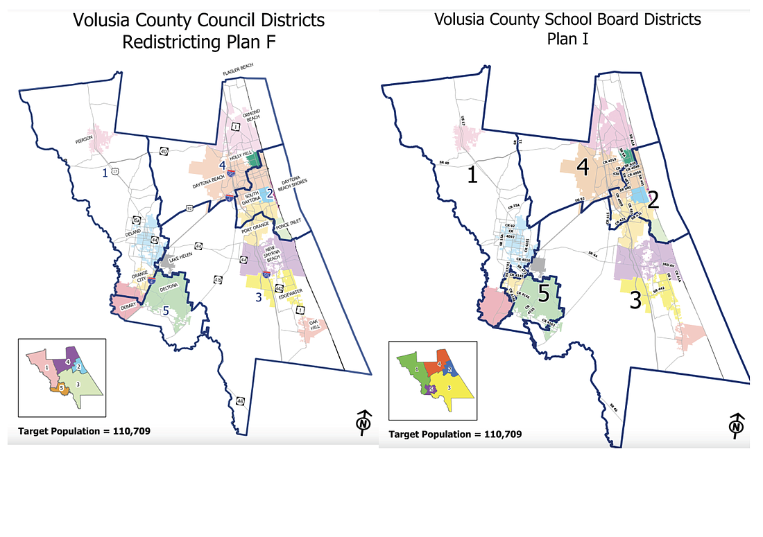
The school board members tended to favor map "I" while the County Council wished to adopt map "F." Both maps kept Districts 2 and 4 (the latter which includes Ormond Beach) mostly the same from the current district map used by the council. The major differences of the maps lie in the west side of the county. Map "I" would move Orange City into District 5 while keeping the city of DeBary entirely in District 1. Map "F" would split DeBary between Districts 1 and 5.
School Board member Carl Persis said population counts and school zones will continue changing into the future. As a result, to make things simpler, he said he was willing to compromise with the council on district lines.
Some council members expressed doubt that a compromise could be reached, but ultimately, Councilman Ben Johnson made a motion to make maps "F" and "I" the new starting points and directed the county’s Geographic Information Services to look into consolidating the two maps into one. The school board made a similar motion, and both passed.
A second joint meeting will be held at 5:30 p.m. on Thursday, Oct. 28, in the first-floor training room of the Thomas C. Kelly Administration Center, at 123 W. Indiana Ave. in DeLand.